The NASA-ISRO Synthetic Aperture Radar (NISAR) satellite has successfully launched from the Satish Dhawan Space Centre in Sriharikota, India at 5:40 PM IST on Wednesday, July 30, 2025. This landmark mission represents a collaborative effort between the Indian Space Research Organisation (ISRO) and NASA to study Earth's land and ice surfaces in unprecedented detail. The satellite was carried into its designated Sun Synchronous Polar Orbit (SSPO) by ISRO's Geosynchronous Satellite Launch Vehicle (GSLV-F16).
NISAR is designed to observe and measure some of the planet's most complex natural processes. Its primary objectives include studying land and ice deformation, land ecosystems, and oceanic regions, addressing areas of common interest to both the U.S. and Indian scientific communities. The mission aims to measure woody biomass changes, track active crops, monitor wetlands, map ice sheets and glaciers, and characterize land surface deformation related to seismic activity, volcanism, landslides, and changes in subsurface aquifers.
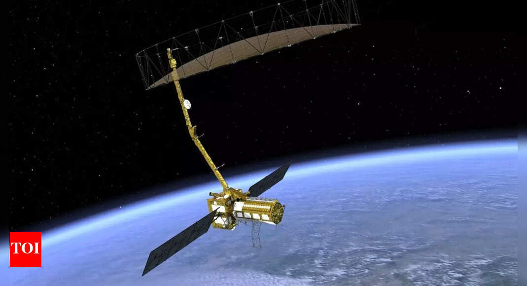
The satellite is equipped with a dual-frequency Synthetic Aperture Radar (SAR). NASA provided the L-band SAR, a high-rate telecommunication subsystem for scientific data, GPS receivers, a solid-state recorder, and a payload data subsystem. ISRO contributed the S-band SAR, the satellite bus, the launch vehicle, and associated launch services. This dual-band system employs an advanced SweepSAR technique, providing high-resolution and large swath imagery. The L-band operates at 1.25 GHz, offering a spatial resolution of 3-48 meters, while the S-band operates at 3.2 GHz with a resolution of 3-24 meters. The wavelengths allow the satellite to penetrate clouds and vegetation, enabling all-weather, day-and-night data acquisition. The satellite will image the global land and ice-covered surfaces, including islands, sea-ice, and selected oceans, every 12 days.
NISAR will orbit in a sun-synchronous dawn-dusk orbit at an altitude of 747 km, with an inclination of 98.4 degrees and a period of 100 minutes. This orbit allows the satellite to scan nearly all of Earth's land and ice surfaces twice every 12 days. The mission is designed for a baseline of 3 years of operation, with a planned mission life of 5 years.
Space scientist and professor RC Kapoor has lauded NISAR as "the most advanced Earth observation satellite". He noted that the satellite would generate a tremendous amount of high-resolution data daily, providing critical insights for scientists, disaster management authorities, policymakers, and environmental researchers. Union Minister Jitendra Singh congratulated ISRO on the successful launch, recognizing NISAR's capacity to penetrate through fogs, dense clouds, and ice layers, making it a pathbreaking enabler for the aviation and shipping sectors.
The first 90 days after launch will be dedicated to commissioning, or In-Orbit Checkout (IOC), to prepare the observatory for science operations. During this phase, the 12-meter diameter reflector will be deployed. Regular maneuvers will be scheduled to maintain the science orbit and avoid conflicts with science observations. The data acquired will be processed and disseminated to the user community with ground station support from both ISRO and NASA. All data from NISAR will be freely available within one to two days after observation, and within hours in case of emergencies like natural disasters.
NISAR's ability to detect even small changes in the Earth's surface will contribute to a wide range of applications, including monitoring infrastructure, agriculture, natural hazards, and climate change. The mission's data will be invaluable for understanding and managing Earth's dynamic systems.